MESA Blog – Barangay Aplaya, Santa Rosa City, Laguna

Barangay Aplaya, Santa Rosa City, Laguna

by Sylvia D. Clemente

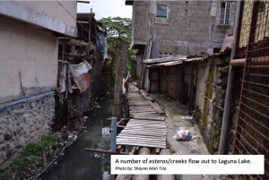
I always ponder on the many contradictions of this small barangay located along the lake shore of Laguna Lake. The first time we visited it’s impossible not to see it as one of the poorer barangays in Santa Rosa as you are greeted by the very narrow streets and alleys, old bridges that cut across a number of silted esteros, dilapidated wooden houses, street hawkers peddling food, and children playing on the streets.  It’s a lively community with its public space full of life as people go about their day-to-day activities and the ubiquitous tricycles darting in and out of the main street.

The main street is the heart of the community and is where you get a glimpse of its character.  Churches of all denominations from Iglesia ni Cristo, Aglipayan Church, to Born Again, line up along this busy street.  The people are very religious, friendly to outsiders, are generally content and do not demand much from the government.  They live and co-exist peacefully regardless of religious denominations.  In a nation that is predominantly Roman Catholic (around 70% because of Spanish colonization), this small barangay appears to be an anomaly.

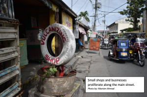
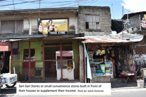
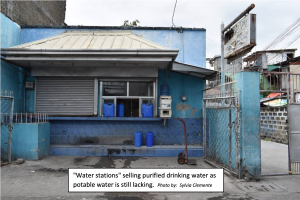
They are resourceful, hardworking, resilient, and self-reliant, no doubt. You can see sari-sari stores(convenience stores), talipapa(small wet markets selling fish, vegetables, and carinderia/home-cook food),  water stations (selling purified drinking water for lack of potable water with majority still using artesian wells), and ambulatory vendors with their makeshift pushcarts sellingkakanin/street food.  Some of the residents work abroad as domestic helpers to support their family back home; the young with limited schooling work in the factories in the light industrial park of Santa Rosa.  Others work in offices,  while some have their small businesses (formal and informal).  There are fewer and fewer fishermen now, so I am told, as Laguna Lake becomes less sustainable for fishing because of its environmental problems (siltation, illegal fishpens, pollution from industries, etc.).  I have personally witnessed the environmental degradation when I went around the Laguna Lake with a fisherman.

For now, the local government approved a PPP (public-private partnership) eco-tourism project to be built along the lakeshore which will reclaim and transform it into a mixed-use/recreational park.  The newly elected barangay president of the Bantay Lawa, a volunteer group of fishermen that police the Laguna Lake against illegal activities, is in favour of it as it will provide them with open/recreational space.  They reminisce about their childhood days when the lakeshore with its parola  used to be a place where people would stroll and rest at the end of the day.  It was a time when the lake was still clear and pristine with an abundance of fish and marine life.


Blog Post from University of Santo Tomas

In the Philippines, at the University of Santo Tomas, we are now well underway with the first stage of our mapping, which is data collection. Our site of Santa Rosa is divided into 18 political districts called barangays. We have combined social research methods (questionnaires and focus group discussions) with desktop analysis of documents such as the land use plan and development plan for the area.

Early in the project, we conducted field reconnaissance surveys in to understand the topography, geology and traffic volume, environmental use (such as open spaces and greenery), and social and economic land use (construction, agricultural trends, industrial and commercial activities). Socio-cultural assets, activities of the informal sector of the economy, types of small businesses, and existing routes were also noted. We also made preliminary investigations into site conditions with infrastructure availability/accessibility (or lack of it) and types of housing (as proxy for income level).

We have also used visual methods. Streets were documented though photography in the 18 barangays. These revealed variations in building forms and streetscapes. Linear street scale  panoramas were prepared for each barangay by stitching photos taken from multiple viewpoints following a linear path along a specific street. Alongside these street views, vehicular and pedestrian routes were traced with the help of the participants of the focus groups. The participants were given a map where they could trace their travel routes from home to work.

The Socio-economic data and environmental profile of the 18 barangays (sub-units or lower administrative units) of the city were collected and analysed in order to provide a basis for the selection of five (5) barangays which will be studied in greater detail. These were chosen according to the following criteria:

  • Geographical location of the barangay in relation to the Laguna Lake,
  • Population and land area ratio,
  • Historical significance,
  • Economic profile;

Based on the field survey and data provided by the city, the barangays can be characterized as described below:

  • Barangay Aplaya located along the Laguna lake shore making it the very susceptible to the risks of flooding. The economic realities present in the Barangay such as those related to fisheries make it an interesting subject of this study.
  • Barangay Kanluran, even though is one of the smallest barangays of Santa Rosa in population and land area, it can be considered the most historical since it partly belongs to the población (the administrative and socio-cultural center of the city since its founding) of the city. Kanluran is home to the ancestral houses of the Zavallas, Tiongcos and Perlas’ to name a few. It is also where the old City Plaza is located in front of the Parish Church of Santa Rosa de Lima, the patroness to whom the city was dedicated.
  • Barangay Dila, a sprawling urban community along the Old National Highway filled with residential enclaves. It is classified as Heavy Commercial based on Land Classification and is home to almost 9% of the total population of Sta. Rosa, the second most populated Barangay of the City.
  • Barangay Balibago may be considered the center of commerce of Sta. Rosa, being connected to the South Luzon Express Way. It is also home to the largest Leisure Park of South Luzon, the Enchanted Kingdom and one of the biggest malls in the city, SM Sta. Rosa.
  • Barangay Sto. Domingo, although has a small population is one of the largest barangays in terms of land area and is identified as one of the heavy industrial mixed-use areas of Sta. Rosa based on land classification and considered as Tourism and Low Density Residential Mixed-Use area based on Land Use. It lies in the western fringe of the city with new residential developments. It is also where the historical Spanish Cuartel de Santo Domingo is located.


Our First MESA Blog Post

Our First MESA Blog Post

What’s been happing in Reading?

Welcome to the very first MESA blog post! We will use this blog to record ongoing activities of the project. My name is Eli and together with Flora and Lorraine, we are the Reading MESA team. In due course I will introduce the team from Santo Tomas in Manila in the Philippines and the work that they are doing. This first post will discuss our initial activities and thoughts here in Reading.

The first steps that we took were aimed at getting a better understanding of the different types of research currently being conducted through maps and mapping, so that we could begin to think about how the work we are doing will relate to, and build upon, current trends. Across disciplines there is a growing interest in using mapping as a way of reflecting upon and researching spatial issues. These issues range, not least, from the from the social to the environmental and cover scales from the statistical to the personal.

As soon as I started looking for maps I found them everywhere. At one level the abundance of different maps and mapping techniques was overwhelming, but at another it was inspiring, since it demonstrates that there is no single ‘correct’ way that we have to do things. This leaves great scope for creatively developing new ideas and approaches.

One interesting outcome of the initial study into research being conducted through mapping was the distinct scarcity of architects doing this type of research, as opposed to the many geographers and social scientists. This led us to the idea that we would focus our attention on methodologies for mapping that could be useful for architect researchers and practitioners and test these methodologies in context at our site in Reading.

The site we have chosen is in central Reading along a stretch of the Kennet and Avon Canal near Orts Road. Over the summer, I got help from a couple of student interns who conducted fieldwork with me. We used our smartphones to gather geolocated photographs that we mapped through software called Mapillary. Following this, we engaged with the public along the canal by setting up duck feeding stations with healthy duck food such as peas and oats. We asked people what they valued most locally, as the first steps toward making a value map.

As the project progresses, lots of different methodologies will be tested and developed, no doubt some will be more successful than others, but the outcome should be a really useful resource for architects who want to map.